In December 2023, the Wisconsin Supreme Court threw out the existing state legislative maps. If the state legislature and governor cannot agree on new maps, the Court ruled that they would choose a remedial map from among a list of submissions.1 Those submissions were due to the Supreme Court on January 12, 2024.
The Court’s majority opinion described a set of criteria that they would use to evaluate the maps. However, they did not define specific metrics. Each party submitting a map was free to choose their own metric when arguing why their plan is best. There are many empirically legitimate ways to measure concepts like compactness and partisan balance. The most important thing is that the measures be applied to each plan in exactly the same way. That is what I have done in the analysis below.
To analyze these plans, I have constructed an open source repository of code and data available here. That repository generates the scorecards below, along with many more metrics. For instance, this file includes the results of each presidential, gubernatorial, US senate, attorney general, and state treasurer race in each proposed district from 2012-2022. I encourage interested readers to explore the complete resource for themselves.
Update 1/18: On January 17, the Court rejected the Petering submission because Matthew Petering was not among the original parties to the case.
Assembly
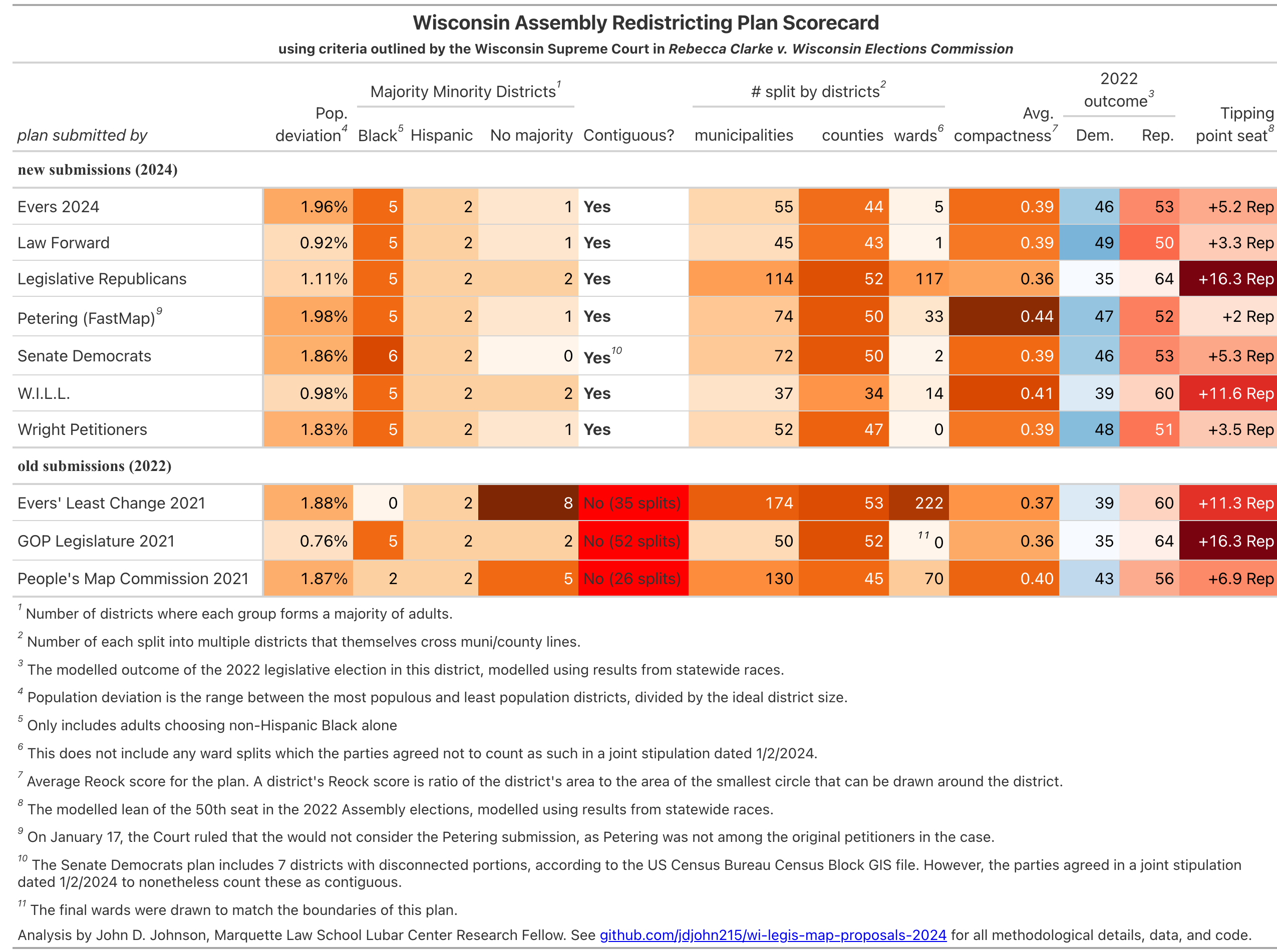
Population Deviation
This measures how well each plan achieved equal populations across districts. It is the range between the most and least populous districts, divided by the ideal district size. Lower numbers are better. The new submissions fall into two camps. The Law Forward, WILL, and Legislative Republican plans each have population deviations close to 1%. The rest of the plans have deviations closer to 2%.
Majority Minority Districts
Federal law requires that, under certain circumstances, districts be drawn where minority voters have the ability to elect candidates of their own choosing. In Wisconsin, that has generally meant 5 districts where Black adults make up a majority and 2 majority Latino districts. All the plans here accomplished that, with the exception of the Senate Democrats plan, which created a sixth majority Black district.
Contiguity
This is one is a simple pass/fail requirement. Every component (census block) of a district must be touching the rest of the district, with the exception of literal physical islands. The old maps were thrown out in December because the Supreme Court chose to interpret the Wisconsin Constitution’s “contiguous territory” requirement literally.
Geographic Splits
It’s impossible to draw contiguous, equal-population districts without splitting counties, municipalities, and wards. But the Court prefers plans to split fewer of them, if possible. Here I measure the number of municipalities, counties, and wards split into multiple districts, which themselves cross into other municipalities or counties. (I don’t count districts which lie entirely within a larger municipality or county).
Across all geographies, the plan submitted by Legislative Republicans has the most splits. WILL’s plan splits the fewest municipalities and counties, but more wards. The Wright Petitioners’ plan splits no wards. These ward split totals do not include splits in wards which the parties agreed not to count in a joint stipulation filed on January 2nd.
Compactness
There are many ways to measure compactness, but they generally show similar rankings. See this table for multiple measures of compactness. In the scorecard below, I show each plan’s average Reock score. The Reock score is the ratio of the district’s area to the area of the smallest circle than can be drawn around the district. A score of 1 equals perfect compactness, so higher numbers are better.
Five of these seven plans have closely clustered Reock scores, between 0.36 and 0.39. The WILL plan achieves an average Reock score of 0.41, and the Petering (FastMap) plan a score of 0.44.
Partisan Balance
The partisan balance of a district could be measured in many ways. Here, I use a statistical model to predict the results of the 2022 state legislative election had they taken place in these proposed districts. I show both the likely number of seats won by each party, as well as the partisan lean of the 50th seat (determining majority control).
The most Republican-leaning plan is, unsurprisingly, the plan submitted by the Wisconsin Legislature. It creates 35 Democratic seats to 64 Republican seats. Democrats would need to carry the state by 16.3 points (58.15% of the two-party vote) in order to win a majority of the Assembly.
The WILL plan slightly softens this Republican advantage, creating 39 Democratic seats to 60 Republican.
All the other plans are more favorable to the Democrats. The most Democratic-leaning plan is the one submitted by Law Forward, which would create (per my model), 49 Democratic seats to 50 Republican ones. Democrats would need to win the state by 3.3 points (51.65%) in order to win a majority.
Senate
The scores for the Senate maps are generally similar. Recall that each Wisconsin State Senate districts consists of three adjacent Assembly districts.
Notably, the Senate Democrats plan and the Petering (FastMap) plans both create outright Democratic majorities, according to my model of the 2022 election. Of course, only even or odd-numbered elections take place in a given election year. The 2024 State Senate elections will cover only the even-numbered districts. Of those 16 seats, 6 are currently held by Democrats and 10 by Republicans. The Wright plan includes the most Democratic-leaning even-numbered seats (10), followed by the Evers and Law Forward plans (9 each).
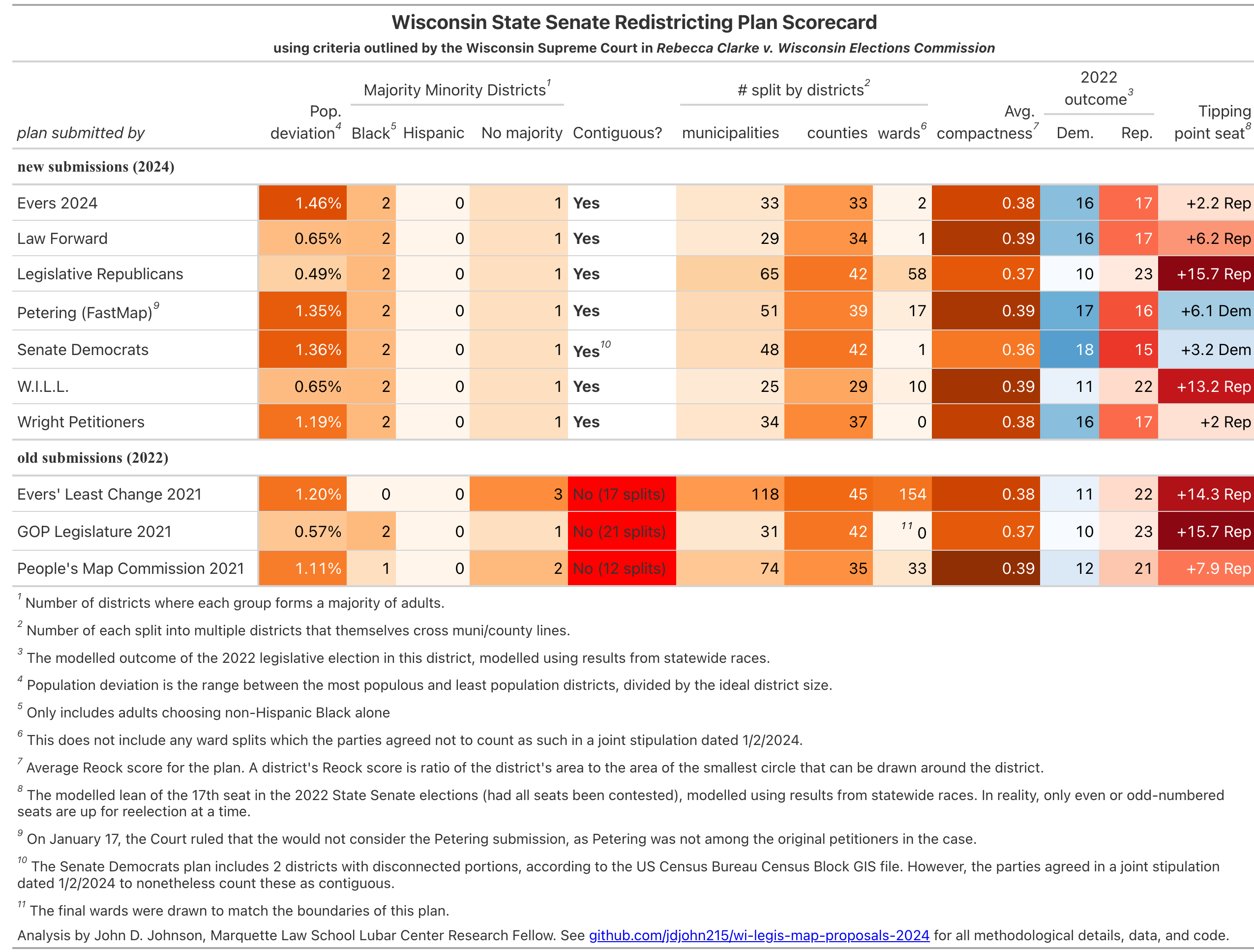
Edit: The plan submitted by the Senate Democrats contains 7 Assembly and 2 Senate districts which are not contiguous according to the Census Bureau’s Census Block GIS file. However, a joint stipulation filed by the parties states that the disconnected census blocks should not actually be counted as noncontiguous. I have accordingly edited these scorecards and this blog post to reflect this. I have also removed these blocks from the list of wards splits in all plans, and I have corrected an error in the calculation of Reock Scores.
Edit 1/18: I have added a footnote explaining the Court’s 1/17 decision to exclude the Petering map.
- If none of the proposed remedial maps satisfy the Court, they may request that their hired consultants draw one as well. ↩︎
I notice the GOP Legislature 2021 plan (the one now in effect I believe) shows 0 Ward Splits for both Assembly and Senate. Am I right in guessing that that is because municipalities adjust the wards to match the districts? I believe that happened here in Wauwatosa where I live. If that’s the case, maybe “n/a” would be more applicable than “0”.
Thanks for this analysis and for publishing your work to github!
Good point. I’ve added a footnote to that effect.
If the law says the legislature draws the maps and not the judicial or executive branches of the government then this action by the Supreme Court would seem unconstitutional. The courts do not get to pick the maps nor does the executive.
It is convenient that this article leaves out that the US Supreme Court overruled the Wisconsin court already doing this exact same thing. They essentially ruled the existing maps are legal. This action by the Wisconsin Supreme Court would seem to this non-lawyer to be entirely partisan legislating. An action they are barred from taking by the existing law.
My guess is any map, other than the one chosen by the existing legislature, will be challenged at the US Supreme Court and be overturned by them, just as it has in the past. These maps affect the us federal election aa well.
The democrats in the state are using the same illegal “lawfare” that is pulled out every time they can not win a legitimate election. The law is very clear on which branch of government gets to draw the maps and it is NOT the judicial or executive. If the courts pick the maps I can honestly say the elections are rigged in Wisconsin as the law was violated to put them in place.
The WI Supreme Court also picked the map in 2022. A panel of 3 federal judges picked the maps in 2000s, 1990s, and 1980s. The State Supreme Court drew the maps in 1964 after Baker v. Carr. In the 1970s, the legislature deadlocked and only passed a map after the State Supreme Court threatened to intervene again.
The US Supreme Court did not overrule the WI Supreme Court for choosing a map in 2022. Rather, they overturned the chosen map (Evers’ Least Change proposal) under federal civil rights law. To avoid this happening again, most of the proposed remedial maps in 2024 leave the minority opportunity districts essentially unchanged.
The US Supreme court ruled on a narrow part of federal law. The per curiam decision said, “We agree that the court committed legal error in its application of decisions of this Court regarding the relationship between the constitutional guarantee of equal protection and the VRA.”
The recent Wisconsin Supreme Court states that maps violate the state constitution. Totally different scenario. The US Supreme Court has denied review other states Supreme Court decisions on
legislative maps when based on state law unless it violates federal law or US Constitution. No where in this decision is any violation of federal law or the US Constitution.
In addition, the US Supreme court recently ruled in North Carolina (Moore v Harper)
The Federal Elections Clause does not vest exclusive and independent authority in state legislatures to set the rules regarding federal elections and therefore did not bar the North Carolina Supreme Court from reviewing the North Carolina Legislature’s congressional districting plans for compliance with North Carolina.
Hi Matthew. The WI Constitution doesn’t require that the maps be only drawn by the legislature, any more that it requires a bill to only be written by the legislature. It’s very common that outside entities provide the text for bills – for example ALEC, which provides legislation for GOP bills across the country. Like any bill, the legislature can choose how it wants to have the maps created. For example, using the Iowa method. So, it’s perfectly acceptable.
The constitution does specify how the maps must be drawn though, and that includes compactness and contiguity. The current maps do not follow the requirements of the constitution, and no one can disagree with that statement. It’s simple and straightforward. (There are also federal requirements, which the current map violates as well, but that is not the case brought before the WI SC.)
So, yes, it is actually the job of the state Supreme Court to rule on constitutional matters, and nothing is more fundamental than the constitutionality of the legislative maps. Step aside from partisanship, and the maps as they stand are a clear and obvious violation of the Wisconsin constitutional requirements.
There are so many factually incorrect things about this comment it’s mind-blowing. Imagine being in such an echo chamber where you accuse democrats of stealing an election while the GOP continues to promote the big lie of a stolen 2020 election. Remember when the WI GOP wanted to impeach a judge elected by their citizens for speaking their opinion? But they won’t impeach any republican judges who have done the same thing for years. Accuse others that what you are guiltily of.
I can honestly say that maps drawn by only the Republican side of the aisle. That in a 50-50 state, and gives the Republicans a super
majority are rigged!
How can you redistrict only the even-numbered Senate Districts? If you do that, then you cannot touch the other districts. You will redistribute the population among the even-numbered districts only? Would that not be difficult to achieve? Or are all Senators having to run in 2024?
All of the districts will be redrawn, even and odd-numbered. But the districts will still hold their usually-scheduled elections, so only the even-numbered seats will be up in 2024. This could create the odd situation where an incumbent senator, elected in 2022, will hold a district until 2026 which they do not actually live in. I don’t know if that causes Constitutional problems or not. I imagine it may be litigated in the future.
I think this is the first time I’ve seen the actual criteria that are being used explained. A while ago I found criteria published by the National Conference of State Legislators (Redistricting Criteria (ncsl.org) that seemed to be very complete and similar to what you describe.
These two criteria are also important and missing from your analysis – did you include them?:
– Preservation of cores of prior districts: This refers to maintaining districts as previously drawn, to the extent possible. This leads to continuity of representation.
– Avoiding pairing incumbents: This refers to avoiding districts that would create contests between incumbents.
You could completely eliminate gerrymandering by removing ethnicity and past/expected voting records as criteria for drawing district boundaries. Maybe you could try this analysis then add back in the data and see what it looked like?
Hi Dave. My analysis reflects the criteria chosen by the Wisconsin Supreme Court in the December opinion, and they don’t consider the preservation of district cores or avoiding paring incumbents. For what it’s worth, it’s no surprise that the National Conference of State Legislators includes these criteria. The one thing Democratic and Republican incumbents can usually agree on is the importance of protecting themselves. However, nonpartisan redistricting advocates often object to considering incumbents at all when drawing new districts.
If you are curious, you can read the Court’s discussion of redistricting principles, beginning on page 43 of the majority opinion. https://www.wicourts.gov/courts/supreme/origact/docs/23ap1399_1222opinion.pdf
Given that both the population of the state and the distribution of party members is not uniform, it is amazing that anything close to creating a Legislature and Senate that reflects voting patterns is achievable. Republican politicians are, of course, claiming gerrymandering. Which I pause at for a second. After all, given over ten years of gerrymandering in a wildly partisan fashion by the Republican Party, they should be experts at it by now. The one issue I have a question about is the municipal splits. Given the population of Milwaukee, Madison and Green Bay, I would expect there to be 9 districts wholly within the boundaries of the City of Milwaukee, 4 districts wholly within the boundaries of City of Madison and 1 district wholly within the boundaries of City of Green Bay. I would also expect that there would be no splits in Municipalities with populations of less than 59,533. It isn’t clear to me that the maps proposed meet these ideals
I think your statements about Majority Minority districts needs a bit more explanation:
You state that generally five African American districts were required in the Milwaukee area. Prior to 2021, under federally court drawn maps there were six African American majority districts. I don’t believe a fully analysis was done during the most recent decade of redistricting on the requirements of African American districts but if they were required, six majority districts could still be drawn.
As far as Latino districts, the court in 2011 was clear that when evaluating Latino/Hispanic areas, it was more proper to consider Citizen Voting Age Population (CVAP) rather than just VAP. At that time the court determined that a CVAP of greater than 60% was appropriate and thus only one Latino district could be drawn at that time. While determining CVAP requires more analysis I think it’s safe to assume that while two Latino districts of are bare 50% VAP might be drawn, only one CVAP district could be drawn and in doing so then prevents a second district of 50% or greater VAP.
Mine is a technical question. Why can’t I see the road names cleary, as well as where the county lines are. Do I have to have a certain version of Windows? Something else?
I know I am not the only one who can not see the names of streets, nor county lines.
Thank you for your help.
Hi Carolyn. I’m not sure what you’re referring to, since this blog post doesn’t feature any maps. Perhaps the map at this link will be helpful for your. If you zoom in, you can see individual street names. https://rpubs.com/jdjohn215/evers-vs-previous-legis-maps