Analysis of Proposed Legislative Redistricting Plans submitted to the Wisconsin Supreme Court
In December 2023, the Wisconsin Supreme Court threw out the existing state legislative maps. If the state legislature and governor cannot agree on new maps, the Court ruled that they would choose a remedial map from among a list of submissions.1 Those submissions were due to the Supreme Court on January 12, 2024.
The Court’s majority opinion described a set of criteria that they would use to evaluate the maps. However, they did not define specific metrics. Each party submitting a map was free to choose their own metric when arguing why their plan is best. There are many empirically legitimate ways to measure concepts like compactness and partisan balance. The most important thing is that the measures be applied to each plan in exactly the same way. That is what I have done in the analysis below.
To analyze these plans, I have constructed an open source repository of code and data available here. That repository generates the scorecards below, along with many more metrics. For instance, this file includes the results of each presidential, gubernatorial, US senate, attorney general, and state treasurer race in each proposed district from 2012-2022. I encourage interested readers to explore the complete resource for themselves.
Update 1/18: On January 17, the Court rejected the Petering submission because Matthew Petering was not among the original parties to the case.
Assembly
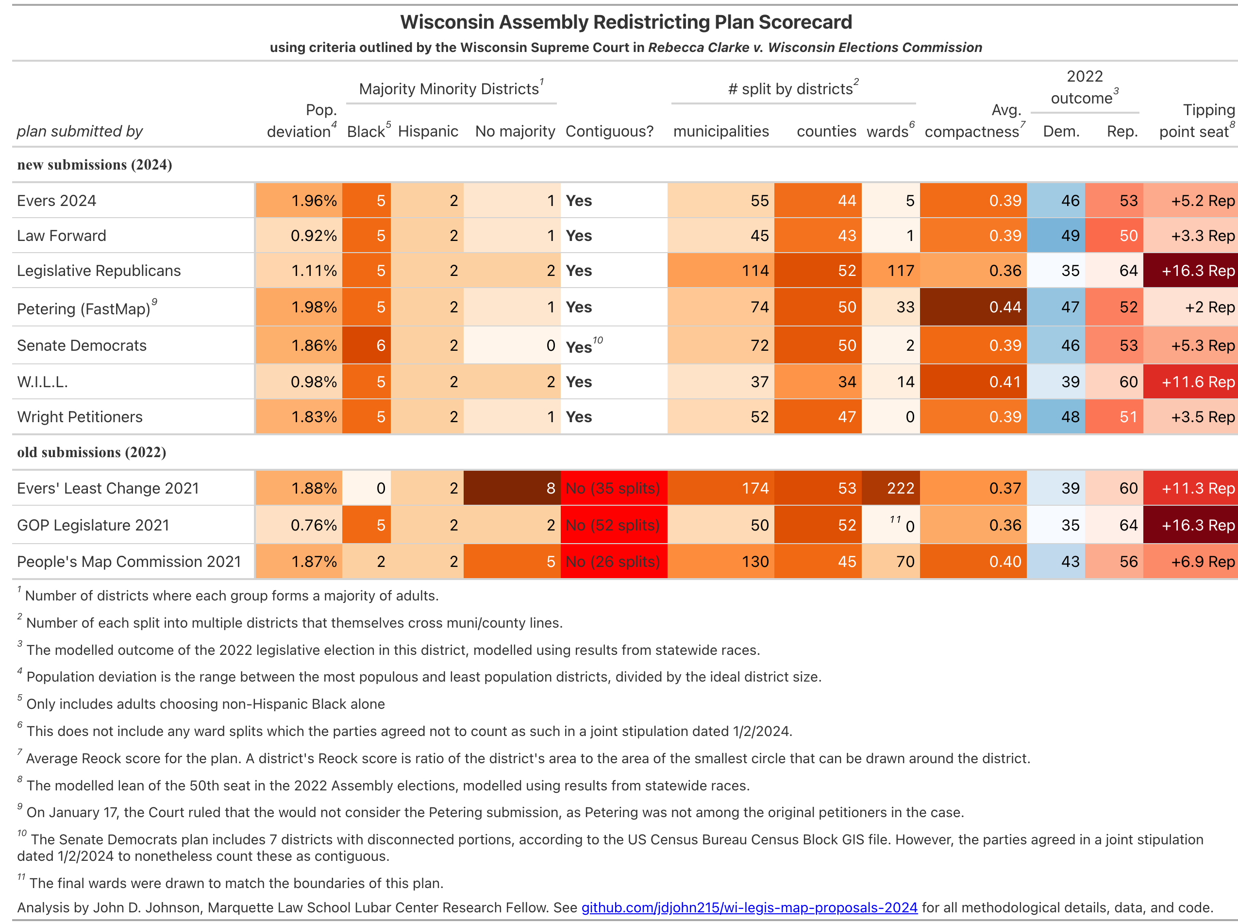
Population Deviation
This measures how well each plan achieved equal populations across districts. It is the range between the most and least populous districts, divided by the ideal district size. Lower numbers are better. The new submissions fall into two camps. The Law Forward, WILL, and Legislative Republican plans each have population deviations close to 1%. The rest of the plans have deviations closer to 2%.
Majority Minority Districts
Federal law requires that, under certain circumstances, districts be drawn where minority voters have the ability to elect candidates of their own choosing. In Wisconsin, that has generally meant 5 districts where Black adults make up a majority and 2 majority Latino districts. All the plans here accomplished that, with the exception of the Senate Democrats plan, which created a sixth majority Black district.
Contiguity
This is one is a simple pass/fail requirement. Every component (census block) of a district must be touching the rest of the district, with the exception of literal physical islands. The old maps were thrown out in December because the Supreme Court chose to interpret the Wisconsin Constitution’s “contiguous territory” requirement literally.
Geographic Splits
It’s impossible to draw contiguous, equal-population districts without splitting counties, municipalities, and wards. But the Court prefers plans to split fewer of them, if possible. Here I measure the number of municipalities, counties, and wards split into multiple districts, which themselves cross into other municipalities or counties. (I don’t count districts which lie entirely within a larger municipality or county).
Across all geographies, the plan submitted by Legislative Republicans has the most splits. WILL’s plan splits the fewest municipalities and counties, but more wards. The Wright Petitioners’ plan splits no wards. These ward split totals do not include splits in wards which the parties agreed not to count in a joint stipulation filed on January 2nd.
Compactness
There are many ways to measure compactness, but they generally show similar rankings. See this table for multiple measures of compactness. In the scorecard below, I show each plan’s average Reock score. The Reock score is the ratio of the district’s area to the area of the smallest circle than can be drawn around the district. A score of 1 equals perfect compactness, so higher numbers are better.
Five of these seven plans have closely clustered Reock scores, between 0.36 and 0.39. The WILL plan achieves an average Reock score of 0.41, and the Petering (FastMap) plan a score of 0.44.
Partisan Balance
The partisan balance of a district could be measured in many ways. Here, I use a statistical model to predict the results of the 2022 state legislative election had they taken place in these proposed districts. I show both the likely number of seats won by each party, as well as the partisan lean of the 50th seat (determining majority control).
The most Republican-leaning plan is, unsurprisingly, the plan submitted by the Wisconsin Legislature. It creates 35 Democratic seats to 64 Republican seats. Democrats would need to carry the state by 16.3 points (58.15% of the two-party vote) in order to win a majority of the Assembly.
The WILL plan slightly softens this Republican advantage, creating 39 Democratic seats to 60 Republican.
All the other plans are more favorable to the Democrats. The most Democratic-leaning plan is the one submitted by Law Forward, which would create (per my model), 49 Democratic seats to 50 Republican ones. Democrats would need to win the state by 3.3 points (51.65%) in order to win a majority.
Senate
The scores for the Senate maps are generally similar. Recall that each Wisconsin State Senate districts consists of three adjacent Assembly districts.
Notably, the Senate Democrats plan and the Petering (FastMap) plans both create outright Democratic majorities, according to my model of the 2022 election. Of course, only even or odd-numbered elections take place in a given election year. The 2024 State Senate elections will cover only the even-numbered districts. Of those 16 seats, 6 are currently held by Democrats and 10 by Republicans. The Wright plan includes the most Democratic-leaning even-numbered seats (10), followed by the Evers and Law Forward plans (9 each).
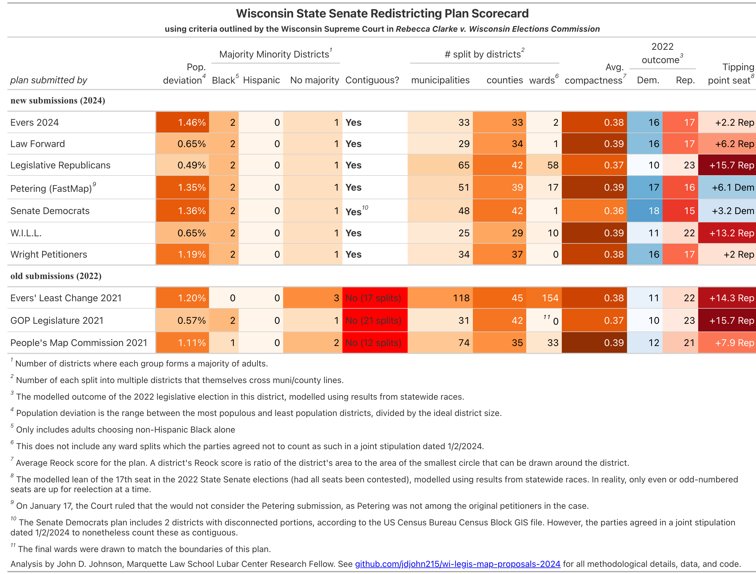
Edit: The plan submitted by the Senate Democrats contains 7 Assembly and 2 Senate districts which are not contiguous according to the Census Bureau’s Census Block GIS file. However, a joint stipulation filed by the parties states that the disconnected census blocks should not actually be counted as noncontiguous. I have accordingly edited these scorecards and this blog post to reflect this. I have also removed these blocks from the list of wards splits in all plans, and I have corrected an error in the calculation of Reock Scores.
Edit 1/18: I have added a footnote explaining the Court’s 1/17 decision to exclude the Petering map.
- If none of the proposed remedial maps satisfy the Court, they may request that their hired consultants draw one as well. ↩︎